Log in
All resources
Create a design
778 Free Artworks of 1870 Maps
the comprehensive history of england (1876)
english-language maps showing history
1870s maps showing history
géographie générale; physique, politique et économique (1876)
den danske hærs historie til nutiden og den norske hærs historie indtil 1814
maps from the earth and its inhabitants, vol. iv
maps from the earth and its inhabitants, vol. xi
1870s maps of scotland
maps from the earth and its inhabitants, vol. ix
1870s maps of france
gemeente atlas van nederland - gelderland
maps of barneveld
the bottom of the sea (1870)
maps of the adriatic sea
den danske hærs historie til nutiden og den norske hærs historie indtil 1814
1870s maps of denmark
den danske hærs historie til nutiden og den norske hærs historie indtil 1814
1870s maps of denmark
maps from the earth and its inhabitants, vol. xvii
1870s maps of the united states
maps from the earth and its inhabitants, vol. iii
1870s maps of berlin
maps from the earth and its inhabitants, vol. xi
1870s maps of morocco
maps from the earth and its inhabitants, vol. xi
1870s maps of morocco
maps from the earth and its inhabitants, vol. iv
1870s maps of the british isles
maps from the earth and its inhabitants, vol. x
1870s maps of ethiopia
maps from the earth and its inhabitants, vol. iv
1870s maps of scotland
maps from the earth and its inhabitants, vol. iv
1870s maps of the british isles
maps from the earth and its inhabitants, vol. xvii
1870s maps of the united states
maps from the earth and its inhabitants, vol. iv
1870s maps of scotland
maps from the earth and its inhabitants, vol. xi
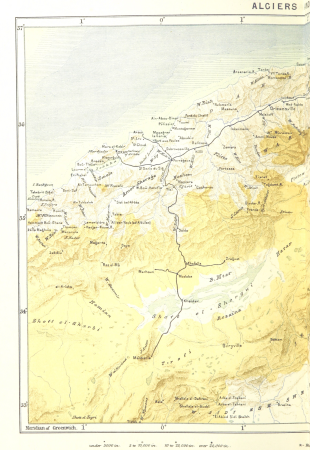
1870s maps of algeria
maps from the earth and its inhabitants, vol. xiv
1870s maps of hawaii
maps from the earth and its inhabitants, vol. xi
1870s maps of algeria
maps from the earth and its inhabitants, vol. iv
1870s maps of the british isles
maps from the earth and its inhabitants, vol. ix
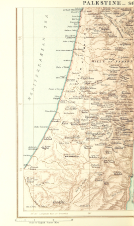
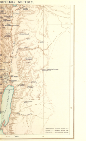
1870s maps of palestine
maps from the earth and its inhabitants, vol. iii
1870s maps of berlin
maps from the earth and its inhabitants, vol. ix
1870s maps of palestine
ghosts & ghoulish scenes
semeuse stamps on covers and postcards (5c)
postcards of charleville-mézières
1870s maps of cuba
guillaume le testu
arctic expeditions from british and foreign shores - from the earliest to the expedition of 1875 (1875)
1870s maps of canada
the comprehensive history of england (1876)
english-language maps showing history
the comprehensive history of england (1876)
english-language maps showing history
the comprehensive history of england (1876)
english-language maps showing history
the comprehensive history of england (1876)
english-language maps showing history
the comprehensive history of england (1876)
english-language maps showing history
the comprehensive history of england (1876)
english-language maps showing history
the comprehensive history of england (1876)
english-language maps showing history
the comprehensive history of england (1876)
english-language maps showing history
the comprehensive history of england (1876)
english-language maps showing history
the comprehensive history of england (1876)
english-language maps showing history
the comprehensive history of england (1876)
english-language maps showing history
1870s maps of egypt
1879 maps of africa
the comprehensive history of england (1876)
english-language maps showing history
the comprehensive history of england (1876)
english-language maps showing history
the comprehensive history of england (1876)
english-language maps showing history
the comprehensive history of england (1876)
english-language maps showing history
the comprehensive history of england (1876)
english-language maps showing history
the comprehensive history of england (1876)
english-language maps showing history
the comprehensive history of england (1876)
english-language maps showing history
the comprehensive history of england (1876)
english-language maps showing history
1877 maps of the united states
1870s maps of utah
the comprehensive history of england (1876)
english-language maps showing history
cuninghame, topographized by timothy pont (1876)
1870s maps of scotland
maps from the earth and its inhabitants, vol. xvii
1870s maps of the united states
old maps of haarlem
haarlemmerhout
media from regionaal archief alkmaar
ruurt de vries
the comprehensive history of england (1876)
english-language maps showing history
maps from the earth and its inhabitants, vol. xiii
south africa in the 1870s
maps from the earth and its inhabitants, vol. xiii
south africa in the 1870s
the bottom of the sea (1870)
maps of the strait of dover
amsterdam impressionism,hague school
maps in the rijksmuseum amsterdam
géographie générale; physique, politique et économique (1876)
basses-pyrénées
1870s maps of kentucky
maps of the ohio river
nouvelle géographie universelle, vol. xvi
1870s maps of colombia
nouvelle géographie universelle, vol. ix
1870s maps of iran
nouvelle géographie universelle, vol. viii
1870s maps of india
nouvelle géographie universelle, vol. vi
1870s maps of armenia
the atlantic islands as resorts of health and pleasure (1878)
1870s maps of the atlantic ocean
den danske hærs historie til nutiden og den norske hærs historie indtil 1814
maps of battles of sweden
géographie générale; physique, politique et économique (1876)
1870s maps of new zealand
géographie générale; physique, politique et économique (1876)
1870s maps of portugal
géographie générale; physique, politique et économique (1876)
1870s maps of france
géographie générale; physique, politique et économique (1876)
1870s maps of scotland
géographie générale; physique, politique et économique (1876)
1870s maps of greece
géographie générale; physique, politique et économique (1876)
1870s maps of cuba
géographie générale; physique, politique et économique (1876)
1870s maps of central america
géographie générale; physique, politique et économique (1876)
1870s maps of france
maps from the earth and its inhabitants, vol. ix
old maps of baghdad
géographie générale; physique, politique et économique (1876)
1870s maps of central asia
géographie générale; physique, politique et économique (1876)
1870s maps of france
géographie générale; physique, politique et économique (1876)
1870s maps of england
maps from the earth and its inhabitants, vol. ix
maps of beirut
géographie générale; physique, politique et économique (1876)
1870s maps of the caucasus
géographie générale; physique, politique et économique (1876)
1870s maps of arabia
the comprehensive history of england (1876)
english-language maps showing history
the comprehensive history of england (1876)
english-language maps showing history
the comprehensive history of england (1876)
english-language maps showing history
the comprehensive history of england (1876)
english-language maps showing history
the comprehensive history of england (1876)
english-language maps showing history
the comprehensive history of england (1876)
english-language maps showing history
the comprehensive history of england (1876)
english-language maps showing history
the comprehensive history of england (1876)
english-language maps showing history
pompeiana - the topography, edifices, and ornaments of pompeii (1817)
old maps of campania
the magazine of american history with notes and queries (1877)
john andré
maps by thomas nast
1872 maps of texas
pompeiana - the topography, edifices, and ornaments of pompeii (1817)
maps of pompeii
den danske hærs historie til nutiden og den norske hærs historie indtil 1814
old maps of helsingborg
den danske hærs historie til nutiden og den norske hærs historie indtil 1814
old maps of rügen
den danske hærs historie til nutiden og den norske hærs historie indtil 1814
old maps of rügen
imperial india; an artist's journals (1879)
pre-raphaelite brotherhood
imperial india; an artist's journals (1879)
pre-raphaelite brotherhood
imperial india; an artist's journals (1879)
pre-raphaelite brotherhood
1870s maps of south africa
emil holub
old maps of the viceroyalty of new spain
the spanish borderlands
pompeiana - the topography, edifices, and ornaments of pompeii (1817)
maps of pompeii
501 - 600 of 778
Next page
/ 8